


[caption id="attachment_8183" align="aligncenter" width="630"]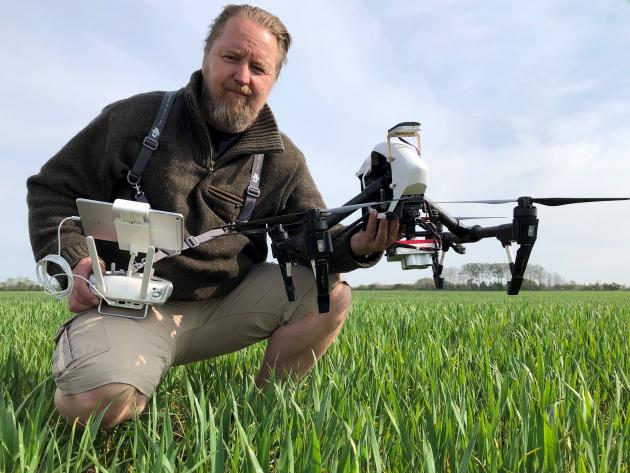 Picture: Per Valentin Lund from Scout Robotics[/caption]
A study from 2019 between the Danish Technological Institute and SEGES shows the economic benefits of using drones in agriculture when gathering data for distributing plant protection. Targeting specific crops instead of the entire field ensures less plant protection waste and economic benefits for the farmer.
With help from drones, it is possible to analyze plants’ photosynthesis and allocate maps that are accurate to fit crops and equipment at any farm. This ensures a higher yield through an intelligent utilization of fertilizer and savings on plant protection.
Earnings can be increased up to DKK 366 per hectare if data from drones are used to analyze where to distribute plant protection over the entire crop along with a graduated spraying. Instead of distributing plant protection evenly, farmers can now target the protection where it is needed and grow better crops.
[caption id="attachment_8184" align="aligncenter" width="630"]
Picture: Per Valentin Lund from Scout Robotics[/caption]
A study from 2019 between the Danish Technological Institute and SEGES shows the economic benefits of using drones in agriculture when gathering data for distributing plant protection. Targeting specific crops instead of the entire field ensures less plant protection waste and economic benefits for the farmer.
With help from drones, it is possible to analyze plants’ photosynthesis and allocate maps that are accurate to fit crops and equipment at any farm. This ensures a higher yield through an intelligent utilization of fertilizer and savings on plant protection.
Earnings can be increased up to DKK 366 per hectare if data from drones are used to analyze where to distribute plant protection over the entire crop along with a graduated spraying. Instead of distributing plant protection evenly, farmers can now target the protection where it is needed and grow better crops.
[caption id="attachment_8184" align="aligncenter" width="630"]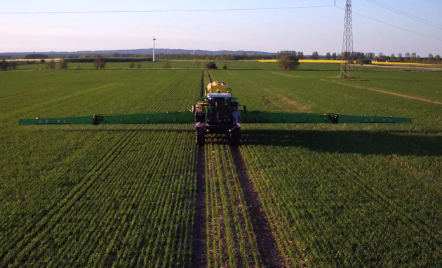 Dronedata increases earnings by up to DKK 366 per. hectares with spray boom with graduation and up to DKK 200 per. hectares without section division.[/caption]
Working smarter than harder
The study examined the difference between using data from satellites and drones since both are used to allocate maps to target the supply of fertilizer and plant protection based on information on growth and soil conditions. By using satellites, the distribution of plant protection is optimized with 36% where drones optimize with 79%. The drone technology delivers higher resolution which secures better results when sorting out lanes and field damages from an allocated map. A reduced amount of plant protection benefits both the environment and provides financial gain as less is wasted.
Scout Robotics is an example of a Danish company who works with photosynthesis analysis and allocated maps that optimize the process. Using the drone technology, they make ready-made allocation maps, working “smarter” than harder. Today Scout Robotics can deliver allocation maps that can be loaded directly into the spray system, already 2-3 hours after they start the overflight of a 40 hectares field.
New customers at Scout Robotics will therefore always be offered help with running-in and start-up, to ensure a good customer experience from the first delivery of allocation cards.
If you want to know more about allocation cards and drones, you are very welcome to contact Scout Robotics at pvl@scoutrobotics.dk or via 30200127 for a non-binding interview. You can also read more at https://scoutrobotics.dk
Source: Online/GFMM
Dronedata increases earnings by up to DKK 366 per. hectares with spray boom with graduation and up to DKK 200 per. hectares without section division.[/caption]
Working smarter than harder
The study examined the difference between using data from satellites and drones since both are used to allocate maps to target the supply of fertilizer and plant protection based on information on growth and soil conditions. By using satellites, the distribution of plant protection is optimized with 36% where drones optimize with 79%. The drone technology delivers higher resolution which secures better results when sorting out lanes and field damages from an allocated map. A reduced amount of plant protection benefits both the environment and provides financial gain as less is wasted.
Scout Robotics is an example of a Danish company who works with photosynthesis analysis and allocated maps that optimize the process. Using the drone technology, they make ready-made allocation maps, working “smarter” than harder. Today Scout Robotics can deliver allocation maps that can be loaded directly into the spray system, already 2-3 hours after they start the overflight of a 40 hectares field.
New customers at Scout Robotics will therefore always be offered help with running-in and start-up, to ensure a good customer experience from the first delivery of allocation cards.
If you want to know more about allocation cards and drones, you are very welcome to contact Scout Robotics at pvl@scoutrobotics.dk or via 30200127 for a non-binding interview. You can also read more at https://scoutrobotics.dk
Source: Online/GFMM


Comment Now